Travelling From Aguas Calientes to Machu Picchu

The small settlement of Aguas Calientes is the closest town to Machu Picchu and the gateway to this spectacular archaeological site. To visit Machu Picchu, you must pass through Aguas Calientes to get there. The only exception is if you’re hiking the 26-mile-long Inca Trail, which runs to the south of the town. Throughout this guide, we’ll look at Aguas Calientes and explore the options available for travel from Aguas Calientes to Machu Picchu. We’ll also look at how to get to this remote town in the first instance, given that there are no roads into the town.

Where is Aguas Calientes?

Aguas Calientes or Machupicchu or Machupicchu Pueblo, as it’s also known, is located 5 miles northeast of Machu Picchu archaeological site.  The town is in the Urubamba Province in the Cusco Region of Peru. The town lies 45 miles northwest of the city of Cusco. 

Map showing the location of Aguas Calientes in Peru

Getting to Machu Picchu from Aguas Calientes

Given both Machu Picchu and Aguas Calientes occupy remote locations, there are only a couple of ways to travel between the two destinations. The quickest and most straightforward of these is by taking a bus along the Carretera a Machu Picchu, while the more vigorous but cheaper option is by hiking to the archaeological site from Aguas Calientes. 

Bus From Aguas Calientes to Machu Picchu

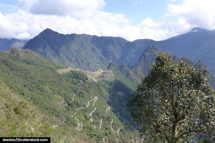
Despite Aguas Calientes being inaccessible to road traffic from the rest of Peru, there is one road that leads out of town, the Carretera a Machu Picchu. Also known as the Hiram Bingham Highway, it runs 5.5 miles from Aguas Calientes to Machu Picchu. Constructed out of asphalt and gravel, the road includes some incredibly steep stretches with 13 hairpin turns as you approach the archaeological site.

Buses are the only permitted method of transport along this route. Operated by a company called Consettur, they ply the route regularly throughout the day. Departures begin at 5.30 a.m., and buses depart every 5 minutes for the first few hours of the day. After this time, buses depart every 10 minutes. They continue throughout the day until the site closes at 5:30 p.m. 

Tickets for the Consettur bus must be bought in advance, either online or via their office at Av. Hermanos Ayar S/N, before the Puente Ruinaso. When you come to catch the bus in the morning, you’ll find that the buses operate on a first-come, first-serve basis. At the start of the day, long queues can form, so either arrive early or be prepared to wait. Likewise, on the return journey, expect long queues at the end of the day.

Both departures and arrivals leave from the bus terminal in Aguas Calientes. It’s easily missed as it’s not very big and it can be found located across from the train station. The journey to and from Machu Picchu takes 30 minutes in both directions and the views along the way are incredible.

Bus fares for foreigners from Aguas Calientes to Machu Picchu are as follows:

Journey

Adult

Child (5-11)

Return Trip

$24

$12

One way up

$12

$7

One way down

$12

$7

Aerial view of the hairpin turns of the Hiram Bingham Highway
The Hiram Bingham Highway contains 13 hairpin turns as it ascends the mountain.

Hike From Aguas Calientes to Machu Picchu

The only alternative to taking a bus up to Machu Picchu is to hike there. It’s a relatively strenuous 5-mile hike from Aguas Calientes to Machu Picchu, and it’s not one for the faint-hearted. However, for those undertaking the hike, it’s hugely rewarding and affords a spectacular route into the lost city. 

The hiking route follows the road out of town to Machu Picchu along the Avenida Hermanos Ayar. You must follow the road until you cross the bridge over the Vilcanota River. While the bus route proceeds up the hairpin turns of the Hiram Bingham Highway, the hiking route turns right and continues down past the Machu Picchu Museum. The trailhead, up the side of the mountain, is located shortly after and is clearly marked. 

From here, it’s a steep ascent up the mountain along a series of stone steps. The path eventually leads to the drop-off location of the buses and, in turn, the spectacular archaeological site of Machu Picchu. The total ascent is almost 400 meters, and the climb is all the more challenging given the altitude. Ideally, you will have spent some time at altitude acclimatizing before attempting the ascent.

The total hiking time from Aguas Calientes to Machu Picchu varies depending on your fitness and the weather conditions. However, expect it to take anywhere between 1.5 hours and 3 hours. The return journey is often shorter, but it can also be tough on your knees, so proceed with care. During the wet season, the hiking route can become very challenging, so check the weather before making the ascent or descent. 

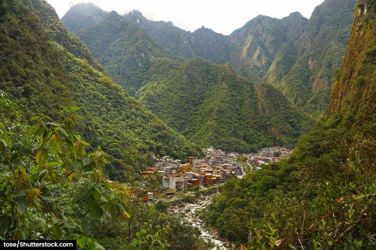
View of the town of Aguas Calientes nestled in the valley
The spectacularly located town of Aguas Calientes is the gateway to Machu Picchu.

Things to do in Aguas Calientes

The main reason for anyone to visit Aguas Calientes is, of course, it’s proximity to the stunning Machu Picchu. However, there are a couple of attractions in town that might persuade you to stick around for a little bit longer. 

Here are the best things to see and do in Aguas Calientes (apart from Machu Picchu):

Hot Springs – Featuring several different pools ranging from 55°F to 99°F in temperature, this is an excellent spot to relax after a long hike. Admission is only $7, so expect a rustic experience in a beautiful setting rather than a full spa experience. If you visit early in the day, you’ll find the hot springs at their quietest and cleanest. The hot springs are situated a short walk north of town.

Museo de Sitio Manuel Chavez Ballon – This small museum is often called the Machu Picchu Museum and is a great place to learn about the city’s history. It’s located south of town on the hiking route to Machu Picchu. Admission is included in the price of your ticket for the Machu Picchu Archaeological site.

Hiking – Besides the hike up to Machu Picchu, there are plenty of other excellent hikes in the area. One of our favorites is the Putucusi Mountain hike, which leads to the top of the mountain next to the Inca ruins. It’s a steep, arduous climb, which includes ascending a wooden ladder with a metal rope. This should only be attempted by experienced hikers. A slightly less challenging but equally enjoyable hike is through the jungle to the Cascadas Allcamayo waterfall. The trail isn’t especially well marked, so bring a map and a compass.

Train to Aguas Calientes

To get to Aguas Calientes directly, you’ll need to travel by train. The town’s remote location in the mountains means there are no roads connecting it with the main Peruvian road network. Instead, you’ll need to catch the train service from Cusco to Aguas Calientes via Ollantaytambo.

The train service is offered through both PeruRail and IncaRail and travels five times daily. It takes 4 hours to complete the journey from Cusco, and it’s certainly a spectacular journey. The train line weaves through the valleys and rises into the mountains before finally arriving in Aguas Calientes. While the train journey is a scenic one, it’s also very costly. Economy tickets from Cusco start at $125, and better seats are considerably more. You’ll need to book ahead as trains often sell out, particularly during the peak season.

Alternatives to the Train to Aguas Calientes

If you’re adamant that you don’t want to take the train to Aguas Calientes, other options are available, but all require some degree of hiking.

Option 1 - Hike the Inca Trail

While Aguas Calientes is considered the gateway to Machu Picchu, it’s possible to bypass the town entirely. If you hike the 26-mile-long Inca Trail, you’ll follow a route south of town that turns north to arrive at Machu Picchu. While you’ll need to return to Aguas Calientes after visiting the archaeological site, you can then hike the short distance to Santa Teresa to continue your onward journey via road rather than rail. 

It’s important to note all hikes along the Inca trail need to be done as part of a guided tour. The cost of the tour is often prohibitive, so this alternative route isn’t going to save you any money versus the train. It will, however, provide you with a spectacular experience.

Option 2 - Travel via Santa Teresa

Traveling via Santa Teresa is now regarded as the alternative way to reach Machu Picchu. While it requires a bit more effort, it’s undoubtedly much cheaper and avoids using the costly train. The main advantage of traveling via Santa Teresa is its connection to the central Peruvian road network. This means you can reach the town via bus or taxi. From the town, you can take a taxi or walk to the hydroelectric power station (Hydroelectrica) before hiking the 6 miles to Aguas Calientes. The walk is mostly flat and well-marked, so it should only take a few hours to complete.

Related Content

Best Time to Visit Uluru

Best Time to go to Darwin

Brisbane to Byron Bay Road Trip

Cairns to Cape Tribulation

Can you Drive to Australia?

Latest Blog Posts

Can you Drive to Morocco?

You can drive to Morocco from the neighboring countries of Spain and Mauritania, but not Algeria, despite a nearly 2000 km long border between the two countries. Travel between Morocco and any of its neighbors comes with its fair share of challenges. At first glance, you could be mistaken for

10 Best National Parks in Western Australia

If you love solitude, amazing landscapes, and vast open spaces, you’re going to love Western Australia. This amazing land, and the northwest in particular, is often referred to as the ‘Last Frontier’. It’s a land of endless remote possibilities and nowhere showcases this better than the amazing array of national

17 Best Things to do in Vlore

The Albanian port city of Vlore is one of Albania’s spectacular coastal highlights. Situated at the northern end of the Albanian Riviera and overlooking the beautiful Bay of Vlore, the city is blessed with a wealth of attractions. The home of Albanian independence and the gateway to the Riviera, the

Can you Drive to Tuktoyaktuk?

You can drive to remote Tuktoyaktuk on the Arctic Ocean using the Inuvik-Tuktoyaktuk Highway, also known as the “Mackenzie Highway” or “Tuk Highway.” The road provides access to Tuktoyaktuk from Inuvik in the Northwest Territories. Inuvik is accessible from mainland Canada by using the Dempster Highway, which runs all the

Can you Drive to Gasparilla Island?

It’s possible to drive to beautiful Gasparilla Island from the nearby Florida mainland using a bridge known as the Boca Grande Causeway. The causeway connects the unincorporated community of Placida on the mainland to the northern tip of Gasparilla Island, allowing vehicles to access the island. There’s a $6 round

Can you Drive to Guyana?

You can drive to Guyana but only from one of the three South American countries with a common land border. The border crossing with neighboring Brazil in the southwest of Guyana is currently the only open crossing. However, it is located in a very remote region. There are currently no

Mastodon